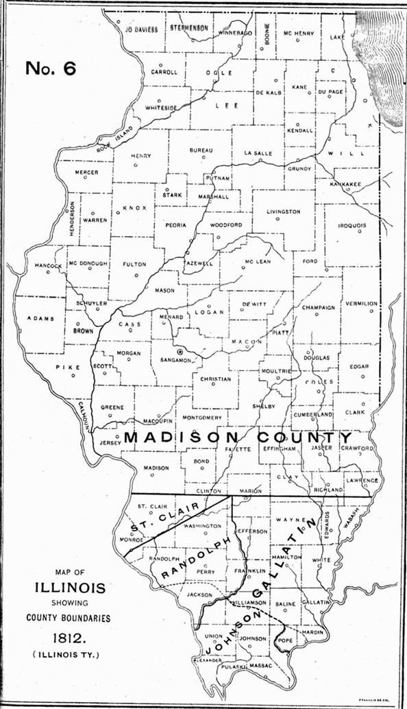
1812 Illinois County Formation Map
Try our genealogy search engine
1812--MADISON, GALLATIN, AND JOHNSON
As counties of the Illinois Territory
A PROCLAMATION
By virtue of the powers vested in the Governor of the Territory, I do hereby lay off a county or district to be called the COUNTY OF MADISON to be included within the following bounds, viz.: To begin on the Mississippi, to run with the second township line above Cahokia east until it strikes the dividing line between the Illinois and Indiana Territories; thence with said dividing line to the line of Upper Canada; thence with said line to the Mississippi; thence down the Mississippi to the beginning. I do appoint the house of Thomas Kirkpatrick to be the seat of justice of said county.
I do also lay off a county or district to be called the COUNTY OF GALLATIN, to be bounded as follows, viz.: To begin at the mouth of Lusk's Creek on the Ohio, running up with said creek to Miles' Trace; thence along said trace to Big Muddy to its source; thence north to the line of St. Clair County; thence with said line to the Wabash; thence down the Wabash and Ohio, to the beginning. And I do appoint Shawnee Town to be the seat of justice of Gallatin County.
And I do lay off a county or district to be called JOHNSON COUNTY to be bounded as follows, viz.: To begin at the mouth of Lusk's Creek on the Ohio; thence with the line of Gallatin County to Big Muddy; thence down Big Muddy and the Mississippi to the mouth of the Ohio, and up the Ohio to the beginning. And I do appoint the house of John Bradshaw to be the seat of justice for Johnson County.
Done at Kaskaskia the 14th day of September, 1812, and the Independence of the United States the thirty-seventh.
By the Governor: NINIAN EDWARDS.
NAT. POPE, Secretary.
[Territorial Records of Illinois, page 26.]