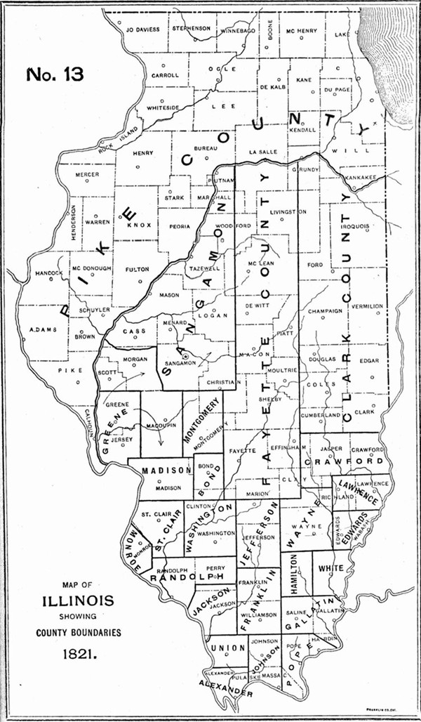
1821 Illinois County Formation Map
Try our genealogy search engine
1821--LAWRENCE, GREENE, SANGAMON, PIKE, HAMILTON, MONTGOMERY AND FAYETTE
As counties of the State of Illinois
LAWRENCE. Jan. 16--Beginning on the Great Wabash seven miles north of the base line, thence west to the Wayne County line; thence north two miles north of town four; thence east to the Wabash; thence with that river to the place of beginning.
[Laws 1821, p. 16.]
Greene. Jan. 20--Beginning at the southeast corner town seven north, ten west of third principal meridian; thence north between ranges nine and ten to the northwest corner of town twelve north; thence west along the line between towns twelve and thirteen to the middle of the Illinois; thence down said river to the Mississippi; thence down the middle of the river to a point parallel with the southwest corner of town six north, ten west; thence north with the range line between ten and eleven, to the township line between six and seven; thence east with said township line to the place of beginning.
[Laws 1821, p. 26.]
SANGAMON. Jan. 30--From the northeast corner of town twelve north, one west of third principal meridian, north with that meridian to the Illinois River; down the middle of the river to mouth of Balance or Negro (Indian) creek; up said creek to its head; thence through the middle of the prairie dividing the waters of the Sangamon and Mauvaise Terre to the north west corner of town twelve north, seven west of the third principal meridian; thence east along the north line of town twelve to the place of beginning.
[Laws 1821, p. 45.]
PIKE. Jan. 31--Up the middle of the Illinois River from its mouth to the fork; up the south fork (Kankakee) to the Indiana state line; north with the state line to the north boundary of the State; west with said state line to the west boundary of the State; thence with said boundary to the place of beginning.
[Laws 1821, p. 59.]
HAMILTON. Feb. 8--South from the southern line of Wayne County, on the line dividing ranges seven and eight east, to Gallatin County; thence west eighteen miles to Franklin; thence north to the Wayne County line; thence east to the beginning.
[Laws 1821, p. 113.]
MONTGOMERY. Feb. 12--West from the southeast corner of section twenty-four, town seven north, two west, to the southwest corner section nineteen, town seven north, four west; thence south to southeast corner to town seven north, five west; thence west to southwest corner of said township; thence north to northwest corner of town twelve north, five west; thence east to northeast corner of town twelve north, two west; thence south to the beginning.
[Laws 1821, p. 142.]
Fayette. Feb. 14--All that tract of country lying north of a line running east from the southwest corner of town three north, one west, to the southeast corner of town three north, six east of the third principal meridian.*
[Laws 1821, p. 164.]
*NOTE--A strict construction of this act would make the entire western boundary of Fayette County the line between ranges one and two west, and extend its northern boundary to the Wisconsin line, thus taking one range of townships from the east side of Sangamon (formed Jan. 30) and cutting Pike (formed Jan. 31) in two. It is probable that the word "unorganized" should be read into the act so as to make it read all that tract of unorganized country lying north," etc. Subsequent acts seem to justify this theory.